Geolocate

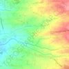
Laguile topographic map

Click on the map to display elevation.

About this map

Name: Laguile topographic map, elevation, terrain.

Location: Laguile, Taal, Batangas, Calabarzon, 4208, Philippines (13.88333 120.89987 13.92333 120.93987)

Average elevation: 38 m

Minimum elevation: 0 m

Maximum elevation: 110 m

Other topographic maps

Click on a map to view its topography, its elevation and its terrain.
Bolbok

Philippines > Batangas > Taal

Average elevation: 117 m

Pansol

Philippines > Batangas > Taal

Average elevation: 69 m

Gear up for your next adventure:

⛺Lightweight Tents - Compact tents for backpacking
📕Hiking Guide Books - Guides for hiking trails
⌚Altimeter Watches - Watches with altitude tracking
🧭Global Orienteering Compass - High-precision liquid-filled compasses for accurate map reading and navigation
🧺Fast-Dry Microfiber Towels - Large towels that pack down to the size of an orange

As an Amazon Associate, this site earns from qualifying purchases at no extra cost to you.