
Aveiro topographic map
Interactive map
Click on the map to display elevation.
About this map
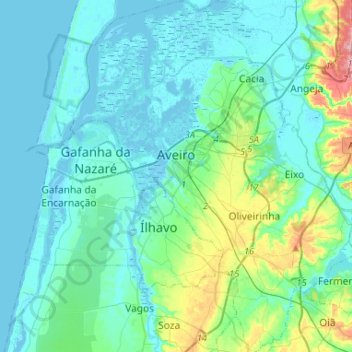
Name: Aveiro topographic map, elevation, terrain.
Location: Aveiro, Portugal (40.52848 -8.76555 40.72755 -8.52096)
Average elevation: 18 m
Minimum elevation: -3 m
Maximum elevation: 111 m
Other topographic maps
Click on a map to view its topography, its elevation and its terrain.
Gamarão de Cima
Gamarão de Cima, Canelas e Espiunca, Arouca, Aveiro, 4540-105, Portugal
Average elevation: 520 m