
Lac d'Allos topographic map
Interactive map
Click on the map to display elevation.
About this map
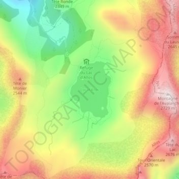
Name: Lac d'Allos topographic map, elevation, terrain.
Average elevation: 2,373 m
Minimum elevation: 2,008 m
Maximum elevation: 2,727 m
Other topographic maps
Click on a map to view its topography, its elevation and its terrain.
Le Seignus d'Allos
France > Provence-Alpes-Côte d'Azur > Alpes-de-Haute-Provence > Allos
Le Seignus d'Allos, Allos, Castellane, Alpes-de-Haute-Provence, Provence-Alpes-Côte d'Azur, France métropolitaine, 04260, France
Average elevation: 1,716 m