Geolocate

Mulmur topographic map

Click on the map to display elevation.

About this map
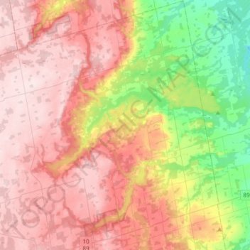
Name: Mulmur topographic map, elevation, terrain.

Location: Mulmur, Dufferin County, Central Ontario, Ontario, Canada (44.08425 -80.21214 44.29490 -79.99249)

Average elevation: 386 m

Minimum elevation: 204 m

Maximum elevation: 531 m

Other topographic maps

Click on a map to view its topography, its elevation and its terrain.
Honeywood

Canada > Ontario > Dufferin County > Mulmur

Average elevation: 505 m

Primrose

Canada > Ontario > Dufferin County > Mulmur

Average elevation: 465 m

Camilla

Canada > Ontario > Dufferin County > Mono

Average elevation: 471 m

Mansfield

Canada > Ontario > Dufferin County > Mulmur

Average elevation: 318 m

Banda

Canada > Ontario > Dufferin County > Mulmur

Average elevation: 266 m

Honeywood

Canada > Ontario > Dufferin County > Mulmur

Average elevation: 505 m

Gear up for your next adventure:

🪑Portable Backpacking Chairs - A comfortable seat for studying maps at the end of the day
🌬️Windbreaker Jackets - Wind protection jackets
🦯Trekking Poles - Walking poles for hiking stability
🩹Blister Prevention Tape - Apply to friction points before they become painful sores
🏃Compression Recovery Socks - Reduce leg fatigue after heavy days of elevation gain

As an Amazon Associate, this site earns from qualifying purchases at no extra cost to you.