
Ruhaama Central topographic map
Interactive map
Click on the map to display elevation.
About this map
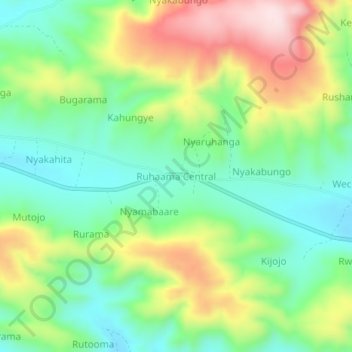
Name: Ruhaama Central topographic map, elevation, terrain.
Location: Ruhaama Central, Ntungamo, Western Region, Uganda (-1.00535 30.32971 -0.96535 30.36971)
Average elevation: 1,559 m
Minimum elevation: 1,421 m
Maximum elevation: 1,791 m
Other topographic maps
Click on a map to view its topography, its elevation and its terrain.