
Bratislava topographic map
Interactive map
Click on the map to display elevation.
About this map
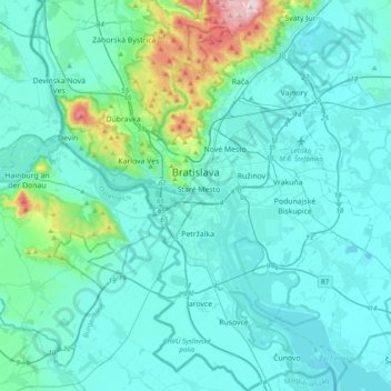
Name: Bratislava topographic map, elevation, terrain.
Location: Bratislava, Region of Bratislava, Slovakia (48.00666 16.94604 48.26507 17.28453)
Average elevation: 172 m
Minimum elevation: 118 m
Maximum elevation: 587 m
The Carpathian mountain range begins in city territory with the Little Carpathians (Malé Karpaty). The Záhorie and Danubian lowlands stretch into Bratislava. The city's lowest point is at the Danube's surface at 126 metres (413 ft) above mean sea level, and the highest point is Devínska Kobyla at 514 metres (1,686 ft). The average altitude is 140 metres (460 ft).
Other topographic maps
Click on a map to view its topography, its elevation and its terrain.
Nové Mesto
Slovakia > Region of Bratislava > District of Bratislava III > Nové Mesto > Nové Mesto
Nové Mesto, District of Bratislava III, Region of Bratislava, Bratislava, 831 04, Slovakia
Average elevation: 177 m
Bratislava
Slovakia > Region of Bratislava
Bratislava, Region of Bratislava, Slovakia
Average elevation: 168 m
Danube
Slovakia > Region of Bratislava > District of Bratislava V
Danube, District of Bratislava V, Bratislava, Region of Bratislava, 850 09, Slovakia
Average elevation: 125 m
Bratislava
Slovakia > Region of Bratislava > District of Bratislava I > Old Town
Bratislava, Old Town, District of Bratislava I, Region of Bratislava, Bratislava, 815 18, Slovakia
Average elevation: 175 m
Senec
Slovakia > Region of Bratislava > Senec
Senec, Region of Bratislava, 90301, Slovakia
Average elevation: 128 m