
Rangamati topographic map
Interactive map
Click on the map to display elevation.
Rangamati
Rangamati (Bengali: রাঙ্গামাটি;) is the administrative headquarter and town of Rangamati Hill District in the Chittagong Hill Tracts of Bangladesh. The town is located at 22°37'60N 92°12'0E and has an altitude of 14 metres (46 ft).
About this map
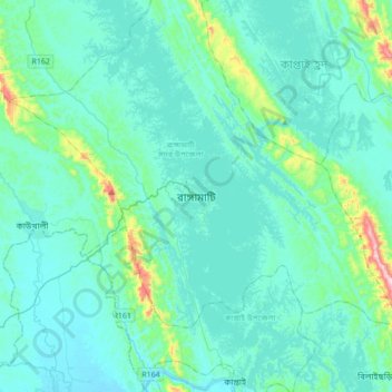
Name: Rangamati topographic map, elevation, terrain.
Average elevation: 68 m
Minimum elevation: 5 m
Maximum elevation: 565 m