Geolocate

Anaheim topographic map

Click on the map to display elevation.

About this map

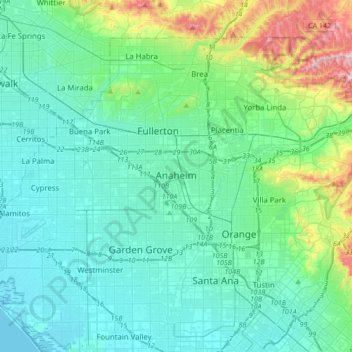
Name: Anaheim topographic map, elevation, terrain.

Location: Anaheim, Orange County, California, United States (33.78892 -118.01736 33.87906 -117.67397)

Average elevation: 89 m

Minimum elevation: -3 m

Maximum elevation: 513 m

Other topographic maps

Click on a map to view its topography, its elevation and its terrain.

Anaheim

United States > California > Orange County > Anaheim

Average elevation: 98 m

Santa Ana

United States > California > Orange County > Santa Ana

Average elevation: 83 m

Gear up for your next adventure:

📚Map Reading & Navigation Guides - Master the art of interpreting topographic contours and symbols
🛠️Outdoor Repair Kits - Gear repair kits
🔋Solar Power Banks - Charge your phone and GPS using the sun while deep in the bush
🧴SPF 50+ Bulk Sunscreen - Maximum protection for long-term outdoor exposure
🔑Heavy Duty Carabiners - Secure gear to the outside of your pack for easy access

As an Amazon Associate, this site earns from qualifying purchases at no extra cost to you.