Geolocate

Sudbury topographic map

Click on the map to display elevation.

About this map

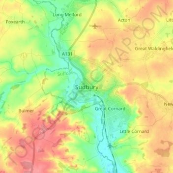
Name: Sudbury topographic map, elevation, terrain.

Location: Sudbury, Babergh, Suffolk, England, CO10 1GL, United Kingdom (52.00015 0.68995 52.08015 0.76995)

Average elevation: 54 m

Minimum elevation: 17 m

Maximum elevation: 93 m

Other topographic maps

Click on a map to view its topography, its elevation and its terrain.

Glemsford

United Kingdom > England > Suffolk > Babergh

Average elevation: 58 m

Brettenham

United Kingdom > England > Suffolk > Babergh

Average elevation: 83 m

Shelley

United Kingdom > England > Suffolk > Babergh

Average elevation: 32 m

Somerton

United Kingdom > England > Suffolk > Babergh

Average elevation: 83 m

Chilton

United Kingdom > England > Suffolk > Babergh > Sudbury

Average elevation: 62 m

Cockfield

United Kingdom > England > Suffolk > Babergh

Average elevation: 85 m

Gear up for your next adventure:

🧺Waterproof Dry Sacks - Organize your pack and keep electronics safe from rain and river crossings
🧢Outdoor Sun Hats - Sun protection hats for hiking
🧥Insulated Down Jackets - High warmth-to-weight ratio for cold nights in the high country
🕶️Polarized Outdoor Sunglasses - Reduce glare from rocks and water for better visual navigation
🧦Merino Wool Hiking Socks - Moisture-wicking socks to prevent blisters during long topographic surveys

As an Amazon Associate, this site earns from qualifying purchases at no extra cost to you.