
Make a donation
Gear up for your next adventure:
As an Amazon Associate, this site earns from qualifying purchases at no extra cost to you.
Lorraine topographic map
Click on the map to display elevation.
Make a donation
Gear up for your next adventure:
As an Amazon Associate, this site earns from qualifying purchases at no extra cost to you.
About this map
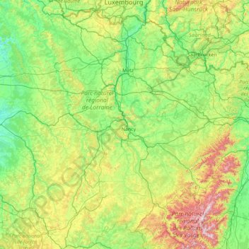
Name: Lorraine topographic map, elevation, terrain.
Location: Lorraine, Metropolitan France, France (47.81369 4.88846 49.61693 7.63882)
Average elevation: 320 m
Minimum elevation: 105 m
Maximum elevation: 1,331 m
Make a donation
Gear up for your next adventure:
As an Amazon Associate, this site earns from qualifying purchases at no extra cost to you.
Other topographic maps
Click on a map to view its topography, its elevation and its terrain.
Make a donation
Gear up for your next adventure:
As an Amazon Associate, this site earns from qualifying purchases at no extra cost to you.
Make a donation
Gear up for your next adventure:
As an Amazon Associate, this site earns from qualifying purchases at no extra cost to you.
Make a donation
Gear up for your next adventure:
As an Amazon Associate, this site earns from qualifying purchases at no extra cost to you.
Make a donation
Gear up for your next adventure:
As an Amazon Associate, this site earns from qualifying purchases at no extra cost to you.
Make a donation
Gear up for your next adventure:
As an Amazon Associate, this site earns from qualifying purchases at no extra cost to you.
Les Résidences
France > Auvergne-Rhône-Alpes > Puy-de-Dôme > Murat-le-Quaire
Average elevation: 1,072 m
Siaugues-Saint-Romain
France > Auvergne-Rhône-Alpes > Haute-Loire > Siaugues-Sainte-Marie
Average elevation: 951 m
Make a donation
Gear up for your next adventure:
As an Amazon Associate, this site earns from qualifying purchases at no extra cost to you.
Make a donation
Gear up for your next adventure:
As an Amazon Associate, this site earns from qualifying purchases at no extra cost to you.
Aix-en-Provence
France > Provence-Alpes-Côte d'Azur > Bouches-du-Rhône > Aix-en-Provence
Average elevation: 279 m
Make a donation
Gear up for your next adventure:
As an Amazon Associate, this site earns from qualifying purchases at no extra cost to you.
Tré-le-Champ - le Haut
France > Auvergne-Rhône-Alpes > Upper Savoy > Chamonix-Mont-Blanc
Average elevation: 1,737 m
Les Baux
France > Pays de la Loire > Loire-Atlantique > Vair-sur-Loire > Saint-Herblon
Average elevation: 50 m
Make a donation
Gear up for your next adventure:
As an Amazon Associate, this site earns from qualifying purchases at no extra cost to you.
La Grave de Peille
France > Provence-Alpes-Côte d'Azur > Maritime Alps > Peille
Average elevation: 400 m
Make a donation
Gear up for your next adventure:
As an Amazon Associate, this site earns from qualifying purchases at no extra cost to you.
Make a donation
Gear up for your next adventure:
As an Amazon Associate, this site earns from qualifying purchases at no extra cost to you.
Make a donation
Gear up for your next adventure:
As an Amazon Associate, this site earns from qualifying purchases at no extra cost to you.
Tré-le-Champ - le Bas
France > Auvergne-Rhône-Alpes > Upper Savoy > Chamonix-Mont-Blanc > Tré-le-Champ - le Bas
Average elevation: 1,724 m
Make a donation
Gear up for your next adventure:
As an Amazon Associate, this site earns from qualifying purchases at no extra cost to you.
Le Planet
France > Auvergne-Rhône-Alpes > Chamonix-Mont-Blanc > Argentière > Le Planet
Average elevation: 1,672 m
Make a donation
Gear up for your next adventure:
As an Amazon Associate, this site earns from qualifying purchases at no extra cost to you.
Paris
Paris in its early history had only the rivers Seine and Bièvre for water. From 1809, the Canal de l'Ourcq provided Paris with water from less-polluted rivers to the north-east of the capital. From 1857, the civil engineer Eugène Belgrand, under Napoleon III, oversaw the construction of a series of new…
Average elevation: 75 m
Make a donation
Gear up for your next adventure:
As an Amazon Associate, this site earns from qualifying purchases at no extra cost to you.
Pierrefitte-Nestalas
France > Occitania > Hautes Pyrenees > Pierrefitte-Nestalas > Pierrefitte-Nestalas
Average elevation: 712 m
La Touche Bourdon
France > Pays de la Loire > Mayenne > Sacé > La Touche Bourdon
Average elevation: 107 m
Make a donation
Gear up for your next adventure:
As an Amazon Associate, this site earns from qualifying purchases at no extra cost to you.
Make a donation
Gear up for your next adventure:
As an Amazon Associate, this site earns from qualifying purchases at no extra cost to you.
La Teste-de-Buch
France > New Aquitaine > Gironde > La Teste-de-Buch > La Teste-de-Buch
Average elevation: 12 m
Make a donation
Gear up for your next adventure:
As an Amazon Associate, this site earns from qualifying purchases at no extra cost to you.
Make a donation
Gear up for your next adventure:
As an Amazon Associate, this site earns from qualifying purchases at no extra cost to you.
Mont Rachet
France > Bourgogne-Franche-Comté > Saône-et-Loire > La Salle > Mont Rachet
Average elevation: 193 m
Gamay
France > Bourgogne-Franche-Comté > Saône-et-Loire > Saint-Sernin-du-Bois > Gamay
Average elevation: 420 m
Make a donation
Gear up for your next adventure:
As an Amazon Associate, this site earns from qualifying purchases at no extra cost to you.
Les Ansaults
France > Centre-Loire Valley > Indre-et-Loire > Artannes-sur-Indre > Les Ansaults
Average elevation: 73 m
Make a donation
Gear up for your next adventure:
As an Amazon Associate, this site earns from qualifying purchases at no extra cost to you.
Eget Village
France > Occitania > Hautes Pyrenees > Aragnouet > Eget Village
Average elevation: 1,560 m
Le Suquet
France > Provence-Alpes-Côte d'Azur > Maritime Alps > Lantosque > Le Suquet
Average elevation: 669 m
Le Petit Cirey
France > Bourgogne-Franche-Comté > Côte-d'Or > Cirey-lès-Nolay
Average elevation: 416 m
Make a donation
Gear up for your next adventure:
As an Amazon Associate, this site earns from qualifying purchases at no extra cost to you.
Clau de Lagleyse
France > New Aquitaine > Lot-et-Garonne > Thézac > Clau de Lagleyse
Average elevation: 202 m
Luchon-Superbagnères
France > Occitania > Haute-Garonne > Saint-Aventin > Luchon-Superbagnères
Average elevation: 1,331 m
Make a donation
Gear up for your next adventure:
As an Amazon Associate, this site earns from qualifying purchases at no extra cost to you.
Le Revest-les-Eaux
France > Provence-Alpes-Côte d'Azur > Var > Le Revest-les-Eaux > Le Revest-les-Eaux
Average elevation: 327 m
La Maranche
France > Auvergne-Rhône-Alpes > Loire > Saint-Bonnet-le-Courreau > La Maranche
Average elevation: 894 m
Make a donation
Gear up for your next adventure:
As an Amazon Associate, this site earns from qualifying purchases at no extra cost to you.
La Pommeraye
France > Bourgogne – Franche-Comté > Saône-et-Loire > Beaurepaire-en-Bresse
Average elevation: 210 m
Make a donation
Gear up for your next adventure:
As an Amazon Associate, this site earns from qualifying purchases at no extra cost to you.