
Make a donation
Gear up for your next adventure:
As an Amazon Associate, this site earns from qualifying purchases at no extra cost to you.
Pickerel River topographic map
Click on the map to display elevation.
Make a donation
Gear up for your next adventure:
As an Amazon Associate, this site earns from qualifying purchases at no extra cost to you.
About this map
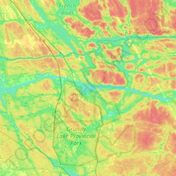
Name: Pickerel River topographic map, elevation, terrain.
Average elevation: 200 m
Minimum elevation: 173 m
Maximum elevation: 230 m
Make a donation
Gear up for your next adventure:
As an Amazon Associate, this site earns from qualifying purchases at no extra cost to you.
Other topographic maps
Click on a map to view its topography, its elevation and its terrain.
Dokis Island
Canada > Ontario > Parry Sound District > Unorganized Centre Parry Sound
Average elevation: 196 m
Port Loring
Canada > Ontario > Parry Sound District > Unorganized Centre Parry Sound
Average elevation: 227 m
Restoule
Canada > Ontario > Parry Sound District > Unorganized Centre Parry Sound
Average elevation: 237 m
Dollars Lake
Canada > Ontario > Parry Sound District > Unorganized Centre Parry Sound
Average elevation: 215 m
Make a donation
Gear up for your next adventure:
As an Amazon Associate, this site earns from qualifying purchases at no extra cost to you.
Stormy Lake
Canada > Ontario > Parry Sound District > Unorganized Centre Parry Sound
Average elevation: 227 m
Arnstein
Canada > Ontario > Parry Sound District > Unorganized Centre Parry Sound
Average elevation: 233 m
Harris Lake
Canada > Ontario > Parry Sound District > Unorganized Centre Parry Sound
Average elevation: 209 m
Whistler Bay
Canada > Ontario > Parry Sound District > Unorganized Centre Parry Sound
Average elevation: 178 m
Make a donation
Gear up for your next adventure:
As an Amazon Associate, this site earns from qualifying purchases at no extra cost to you.
Grundy Lake Provincial Park
Canada > Ontario > Parry Sound District > Unorganized Centre Parry Sound
Average elevation: 197 m
Bosworth Island
Canada > Ontario > Parry Sound District > Unorganized Centre Parry Sound
Average elevation: 224 m
Spring Lake
Canada > Ontario > Parry Sound District > Unorganized Centre Parry Sound
Average elevation: 317 m
Memesagamesing Lake Dam
Canada > Ontario > Parry Sound District > Unorganized Centre Parry Sound
Average elevation: 227 m
Make a donation
Gear up for your next adventure:
As an Amazon Associate, this site earns from qualifying purchases at no extra cost to you.
Dollars Lake
Canada > Ontario > Parry Sound District > Unorganized Centre Parry Sound
Average elevation: 215 m
Jack's Ridge
Canada > Ontario > Parry Sound District > Unorganized Centre Parry Sound
Average elevation: 254 m
Restoule Lake
Canada > Ontario > Parry Sound District > Unorganized Centre Parry Sound
Average elevation: 245 m
Smith Bay
Canada > Ontario > Parry Sound District > Unorganized Centre Parry Sound
Average elevation: 217 m
Make a donation
Gear up for your next adventure:
As an Amazon Associate, this site earns from qualifying purchases at no extra cost to you.
Recollet Falls
Canada > Ontario > Parry Sound District > Unorganized Centre Parry Sound
Average elevation: 206 m
Loring
Canada > Ontario > Parry Sound District > Unorganized Centre Parry Sound
Average elevation: 241 m
Key Harbour
Canada > Ontario > Parry Sound District > Unorganized Centre Parry Sound
Average elevation: 178 m
Clear Lake
Canada > Ontario > Parry Sound District > Unorganized Centre Parry Sound
Average elevation: 222 m
Make a donation
Gear up for your next adventure:
As an Amazon Associate, this site earns from qualifying purchases at no extra cost to you.
Magee Island
Canada > Ontario > Parry Sound District > Unorganized Centre Parry Sound
Average elevation: 196 m
Jack's Ridge
Canada > Ontario > Parry Sound District > Unorganized Centre Parry Sound
Average elevation: 254 m
Jack's Ridge
Canada > Ontario > Parry Sound District > Unorganized Centre Parry Sound
Average elevation: 254 m
Make a donation
Gear up for your next adventure:
As an Amazon Associate, this site earns from qualifying purchases at no extra cost to you.