
Make a donation
Gear up for your next adventure:
As an Amazon Associate, this site earns from qualifying purchases at no extra cost to you.
Thomas Landing topographic map
Click on the map to display elevation.
Make a donation
Gear up for your next adventure:
As an Amazon Associate, this site earns from qualifying purchases at no extra cost to you.
About this map
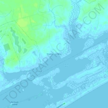
Name: Thomas Landing topographic map, elevation, terrain.
Location: Thomas Landing, Onslow County, North Carolina, United States (34.46683 -77.49635 34.50683 -77.45635)
Average elevation: 2 m
Minimum elevation: -4 m
Maximum elevation: 10 m
Make a donation
Gear up for your next adventure:
As an Amazon Associate, this site earns from qualifying purchases at no extra cost to you.
Other topographic maps
Click on a map to view its topography, its elevation and its terrain.
Make a donation
Gear up for your next adventure:
As an Amazon Associate, this site earns from qualifying purchases at no extra cost to you.
Pumpkin Center
United States > North Carolina > Onslow County > Pumpkin Center
Average elevation: 10 m
Make a donation
Gear up for your next adventure:
As an Amazon Associate, this site earns from qualifying purchases at no extra cost to you.
Marine Corps Base Camp Lejeune
United States > North Carolina > Onslow County > Marine Corps Base Camp Lejeune
Average elevation: 7 m
Make a donation
Gear up for your next adventure:
As an Amazon Associate, this site earns from qualifying purchases at no extra cost to you.
Onslow Beach
United States > North Carolina > Onslow County > North Topsail Beach
Average elevation: 2 m