
Mesa Redondita topographic map
Interactive map
Click on the map to display elevation.
About this map
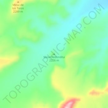
Name: Mesa Redondita topographic map, elevation, terrain.
Location: Mesa Redondita, McKinley County, New Mexico, United States (35.52664 -107.81567 35.52674 -107.81557)
Average elevation: 2,225 m
Minimum elevation: 2,162 m
Maximum elevation: 2,358 m
Other topographic maps
Click on a map to view its topography, its elevation and its terrain.
Tekapo
United States > New Mexico > McKinley County
Tekapo, McKinley County, New Mexico, United States
Average elevation: 1,900 m
Umbrella Rock
United States > New Mexico > McKinley County
Umbrella Rock, Eastern Navajo Agency, McKinley County, New Mexico, United States
Average elevation: 2,168 m
Smith Lake
United States > New Mexico > McKinley County
Smith Lake, Eastern Navajo Agency, McKinley County, New Mexico, United States
Average elevation: 2,221 m
China Springs
United States > New Mexico > McKinley County
China Springs, McKinley County, New Mexico, 87317, United States
Average elevation: 2,065 m
Crownpoint
United States > New Mexico > McKinley County > Crownpoint
Crownpoint, Eastern Navajo Agency, McKinley County, New Mexico, 87313, United States
Average elevation: 2,099 m
Zuni Pueblo
United States > New Mexico > McKinley County > Zuni
Zuni Pueblo, Zuni, McKinley County, New Mexico, 87327, United States
Average elevation: 1,944 m
Fort Wingate
United States > New Mexico > McKinley County > Fort Wingate
Fort Wingate, McKinley County, New Mexico, 87316, United States
Average elevation: 2,156 m
Tinian
United States > New Mexico > McKinley County
Tinian, Eastern Navajo Agency, McKinley County, New Mexico, United States
Average elevation: 2,014 m