
Make a donation
Gear up for your next adventure:
As an Amazon Associate, this site earns from qualifying purchases at no extra cost to you.
Mount Olive topographic map
Click on the map to display elevation.
Make a donation
Gear up for your next adventure:
As an Amazon Associate, this site earns from qualifying purchases at no extra cost to you.
About this map
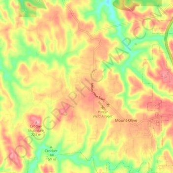
Name: Mount Olive topographic map, elevation, terrain.
Location: Mount Olive, Jefferson County, Alabama, United States (33.64204 -86.90626 33.71966 -86.84161)
Average elevation: 165 m
Minimum elevation: 101 m
Maximum elevation: 218 m
Make a donation
Gear up for your next adventure:
As an Amazon Associate, this site earns from qualifying purchases at no extra cost to you.
Other topographic maps
Click on a map to view its topography, its elevation and its terrain.
Windsor Highlands
United States > Alabama > Jefferson County > Homewood > Windsor Highlands
Average elevation: 240 m
Valley Creek
United States > Alabama > Jefferson County > Birmingham > Graymont
Average elevation: 181 m
Make a donation
Gear up for your next adventure:
As an Amazon Associate, this site earns from qualifying purchases at no extra cost to you.