
Thieu topographic map
Interactive map
Click on the map to display elevation.
About this map
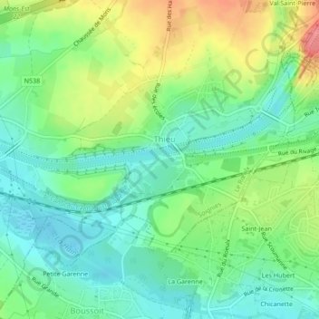
Name: Thieu topographic map, elevation, terrain.
Location: Thieu, Le Rœulx, Soignies, Hainaut, Wallonie, 7070, Belgique (50.47147 4.09140 50.47166 4.09203)
Average elevation: 70 m
Minimum elevation: 40 m
Maximum elevation: 123 m
Other topographic maps
Click on a map to view its topography, its elevation and its terrain.
Château d'Havré
Belgique > Wallonie > Le Rœulx
Château d'Havré, Chaussée du Rœulx, Havré, Le Rœulx, Soignies, Hainaut, Wallonie, 7070, Belgique
Average elevation: 57 m