
Thank you for supporting this site ❤️
Make a donation
Make a donation
Gear up for your next adventure:
As an Amazon Associate, this site earns from qualifying purchases at no extra cost to you.
Kehancha topographic map
Click on the map to display elevation.
Thank you for supporting this site ❤️
Make a donation
Make a donation
Gear up for your next adventure:
As an Amazon Associate, this site earns from qualifying purchases at no extra cost to you.
About this map
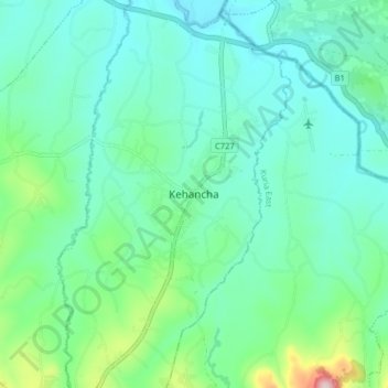
Name: Kehancha topographic map, elevation, terrain.
Location: Kehancha, Bukira East ward, Kuria West, Migori County, Kenya (-1.23326 34.58001 -1.15326 34.66001)
Average elevation: 1,468 m
Minimum elevation: 1,402 m
Maximum elevation: 1,726 m
Thank you for supporting this site ❤️
Make a donation
Make a donation
Gear up for your next adventure:
As an Amazon Associate, this site earns from qualifying purchases at no extra cost to you.