
Innsbruck topographic map
Interactive map
Click on the map to display elevation.
About this map
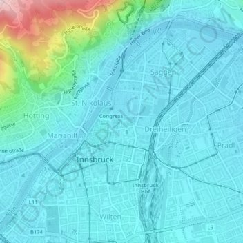
Name: Innsbruck topographic map, elevation, terrain.
Location: Innsbruck, Statutarstadt Innsbruck, Tyrol, Autriche (47.25837 11.38119 47.28086 11.41818)
Average elevation: 611 m
Minimum elevation: 567 m
Maximum elevation: 878 m
La ville est située entre le massif Karwendel au nord et les premiers contreforts de la chaîne centrale des Alpes (Patscherkofel) au sud, à une altitude de 574 m.
Other topographic maps
Click on a map to view its topography, its elevation and its terrain.