
Make a donation
Gear up for your next adventure:
As an Amazon Associate, this site earns from qualifying purchases at no extra cost to you.
Tonalá topographic map
Click on the map to display elevation.
Make a donation
Gear up for your next adventure:
As an Amazon Associate, this site earns from qualifying purchases at no extra cost to you.
Tonalá
The municipality is located in the eastern part of the state. With an average altitude of 1.500 meters above sea level, the territory has three kinds of relief: areas of rugged terrain, semi flat and flat areas. The main elevations are the Cerro Cúpula de la Reina, and Xólotl, both 1,720 meters above sea level.
Make a donation
Gear up for your next adventure:
As an Amazon Associate, this site earns from qualifying purchases at no extra cost to you.
About this map
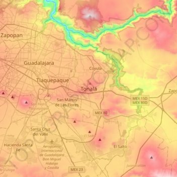
Name: Tonalá topographic map, elevation, terrain.
Location: Tonalá, Región Centro, Jalisco, 45400, Mexico (20.46414 -103.40213 20.78414 -103.08213)
Average elevation: 1,547 m
Minimum elevation: 956 m
Maximum elevation: 2,061 m
Make a donation
Gear up for your next adventure:
As an Amazon Associate, this site earns from qualifying purchases at no extra cost to you.