
Augst topographic map
Interactive map
Click on the map to display elevation.
About this map
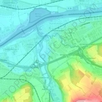
Name: Augst topographic map, elevation, terrain.
Location: Augst, Bezirk Liestal, Basel-Landschaft, 4302, Schweiz (47.52267 7.68682 47.53978 7.73428)
Average elevation: 295 m
Minimum elevation: 258 m
Maximum elevation: 419 m
Zwischen der Ergolz und dem Violenbach liegt eine rund einen Quadratkilometer grosse Ebene, auf welcher die höher gelegenen Quartiere der römischen Stadt Augusta Raurica standen.
Other topographic maps
Click on a map to view its topography, its elevation and its terrain.
Liestal
Schweiz > Basel-Landschaft > Bezirk Liestal
Liestal, Bezirk Liestal, Basel-Landschaft, 4410, Schweiz
Average elevation: 434 m