
Jayena topographic map
Interactive map
Click on the map to display elevation.
About this map
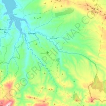
Name: Jayena topographic map, elevation, terrain.
Location: Jayena, Comarca de Alhama, Granada, Andalucía, España (36.86703 -3.85112 36.99447 -3.74364)
Average elevation: 1,092 m
Minimum elevation: 818 m
Maximum elevation: 1,760 m
Other topographic maps
Click on a map to view its topography, its elevation and its terrain.
La Malahá
España > Andalucía > Comarca de Alhama
La Malahá, Comarca de Alhama, Granada, Andalucía, España
Average elevation: 779 m
Játar
España > Andalucía > Comarca de Alhama
Játar, Comarca de Alhama, Granada, Andalucía, España
Average elevation: 1,008 m