
Sege topographic map
Interactive map
Click on the map to display elevation.
About this map
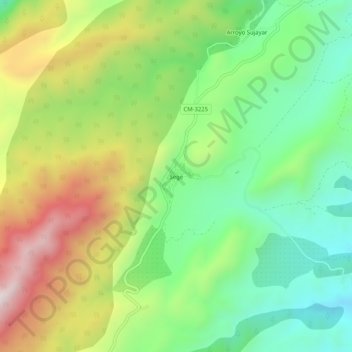
Name: Sege topographic map, elevation, terrain.
Location: Sege, Yeste, Albacete, Castilla-La Mancha, España (38.27527 -2.31449 38.31527 -2.27449)
Average elevation: 1,013 m
Minimum elevation: 732 m
Maximum elevation: 1,441 m
Other topographic maps
Click on a map to view its topography, its elevation and its terrain.
Los Argüellos
España > Castilla-La Mancha > Yeste
Los Argüellos, Yeste, Albacete, Castilla-La Mancha, España
Average elevation: 671 m