
Cantumarca topographic map
Interactive map
Click on the map to display elevation.
About this map
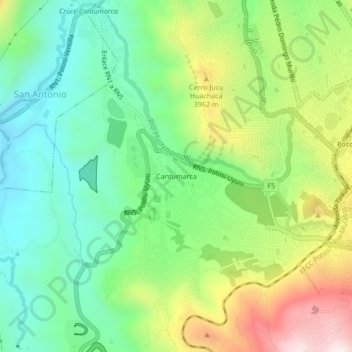
Name: Cantumarca topographic map, elevation, terrain.
Location: Cantumarca, Potosí, Provincia Tomás Frías, Potosí, Bolivia (-19.60499 -65.80012 -19.56499 -65.76012)
Average elevation: 3,797 m
Minimum elevation: 3,563 m
Maximum elevation: 4,212 m
Other topographic maps
Click on a map to view its topography, its elevation and its terrain.
Laguna Masoni
Bolivia > Potosí > Provincia Tomás Frías > Potosí
Laguna Masoni, Potosí, Provincia Tomás Frías, Potosí, Bolivia
Average elevation: 4,756 m