
Greenville topographic map
Interactive map
Click on the map to display elevation.
About this map
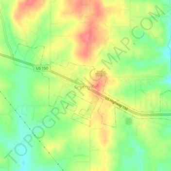
Name: Greenville topographic map, elevation, terrain.
Location: Greenville, Floyd County, Indiana, 47124, United States (38.36504 -86.00349 38.38040 -85.96371)
Average elevation: 245 m
Minimum elevation: 211 m
Maximum elevation: 278 m
Other topographic maps
Click on a map to view its topography, its elevation and its terrain.
Floyds Knobs
United States > Indiana > Floyd County
Floyds Knobs, Floyd County, Indiana, 47146, United States
Average elevation: 251 m
Georgetown
United States > Indiana > Floyd County
Georgetown, Floyd County, Indiana, 47122, United States
Average elevation: 248 m
Galena
United States > Indiana > Floyd County
Galena, Floyd County, Indiana, United States
Average elevation: 232 m
New Albany
United States > Indiana > Floyd County
New Albany, Floyd County, Indiana, 47150, United States
Average elevation: 180 m
Silver Hills
United States > Indiana > Floyd County > New Albany
Silver Hills, New Albany, Floyd County, Indiana, 47150, United States
Average elevation: 160 m
Edwardsville
United States > Indiana > Floyd County
Edwardsville, Floyd County, Indiana, United States
Average elevation: 249 m