
Thank you for supporting this site ❤️
Make a donation
Make a donation
Gear up for your next adventure:
As an Amazon Associate, this site earns from qualifying purchases at no extra cost to you.
Müncheberg topographic map
Click on the map to display elevation.
Thank you for supporting this site ❤️
Make a donation
Make a donation
Gear up for your next adventure:
As an Amazon Associate, this site earns from qualifying purchases at no extra cost to you.
About this map
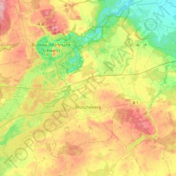
Name: Müncheberg topographic map, elevation, terrain.
Location: Müncheberg, Märkisch-Oderland, Brandenburg, 15374, Germany (52.44653 13.95264 52.60124 14.25912)
Average elevation: 61 m
Minimum elevation: 5 m
Maximum elevation: 128 m
Thank you for supporting this site ❤️
Make a donation
Make a donation
Gear up for your next adventure:
As an Amazon Associate, this site earns from qualifying purchases at no extra cost to you.