
Make a donation
Gear up for your next adventure:
As an Amazon Associate, this site earns from qualifying purchases at no extra cost to you.
Kapoeta topographic map
Click on the map to display elevation.
Make a donation
Gear up for your next adventure:
As an Amazon Associate, this site earns from qualifying purchases at no extra cost to you.
Kapoeta
The town lies on the east bank of the Singaita River. The post at Kapoeta was established by Captain Knollys, who reached the river in January 1927. This location lies approximately 275 kilometres (171 mi), by road, east of Juba, the capital of South Sudan, and the largest city in that country. The town sits at an elevation of 677 metres (2,221 ft) above sea level.
Make a donation
Gear up for your next adventure:
As an Amazon Associate, this site earns from qualifying purchases at no extra cost to you.
About this map
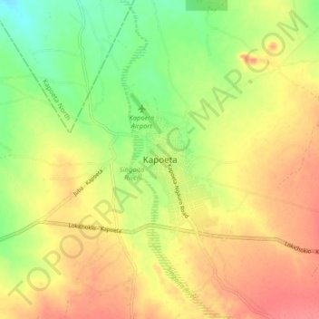
Name: Kapoeta topographic map, elevation, terrain.
Location: Kapoeta, Kapoeta South, Eastern Equatoria, South Sudan (4.72910 33.54997 4.80910 33.62997)
Average elevation: 671 m
Minimum elevation: 637 m
Maximum elevation: 698 m
Make a donation
Gear up for your next adventure:
As an Amazon Associate, this site earns from qualifying purchases at no extra cost to you.