
Klippan topographic map
Interactive map
Click on the map to display elevation.
About this map
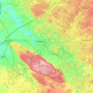
Name: Klippan topographic map, elevation, terrain.
Location: Klippan, Comté de Scanie, Götaland, Suède (56.00100 12.98111 56.23151 13.52251)
Average elevation: 84 m
Minimum elevation: 0 m
Maximum elevation: 210 m
Other topographic maps
Click on a map to view its topography, its elevation and its terrain.
Kristianstad
Suède > Comté de Scanie > Kristianstad
Kristianstad, Comté de Scanie, Götaland, SE-291 31, Suède
Average elevation: 6 m
Simrishamn
Suède > Comté de Scanie > Simrishamn
Simrishamn, Comté de Scanie, Götaland, 27231, Suède
Average elevation: 17 m