
Make a donation
Gear up for your next adventure:
As an Amazon Associate, this site earns from qualifying purchases at no extra cost to you.
Madulain topographic map
Click on the map to display elevation.
Make a donation
Gear up for your next adventure:
As an Amazon Associate, this site earns from qualifying purchases at no extra cost to you.
Madulain
Before 2017, the municipality was located in the Oberengadin sub-district of the Maloja district, after 2017 it was part of the Maloja Region. It is the smallest of the eleven municipalities in the district. It is located in the upper Engadin valley between La Punt Chamues-ch and Zuoz about 15 minutes from St. Moritz on the Inn River. It consists of the Haufendorf village (an irregular, unplanned and quite closely packed village, built around a central square) of Madulain on the Inn at an elevation of 1,684 m (5,525 ft). Until 1943 Madulain was known as Madulein.
Make a donation
Gear up for your next adventure:
As an Amazon Associate, this site earns from qualifying purchases at no extra cost to you.
About this map
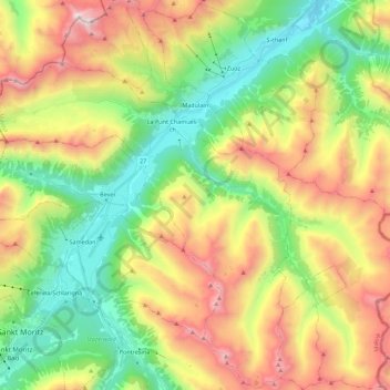
Name: Madulain topographic map, elevation, terrain.
Location: Madulain, Maloja, Grisons, 7523, Switzerland (46.47497 9.89879 46.62785 10.02502)
Average elevation: 2,330 m
Minimum elevation: 1,627 m
Maximum elevation: 3,393 m
Make a donation
Gear up for your next adventure:
As an Amazon Associate, this site earns from qualifying purchases at no extra cost to you.