
Wietzenbruch topographic map
Interactive map
Click on the map to display elevation.
About this map
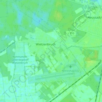
Name: Wietzenbruch topographic map, elevation, terrain.
Average elevation: 40 m
Minimum elevation: 35 m
Maximum elevation: 44 m
Other topographic maps
Click on a map to view its topography, its elevation and its terrain.
Henneckenmoor bei Scheuen
Deutschland > Niedersachsen > Landkreis Celle > Celle
Henneckenmoor bei Scheuen, Arlohstraße, Übungsdorf Neu-Tsellis, Scheuen, Celle, Landkreis Celle, Niedersachsen, 29229, Deutschland
Average elevation: 64 m