
Leuk topographic map
Interactive map
Click on the map to display elevation.
About this map
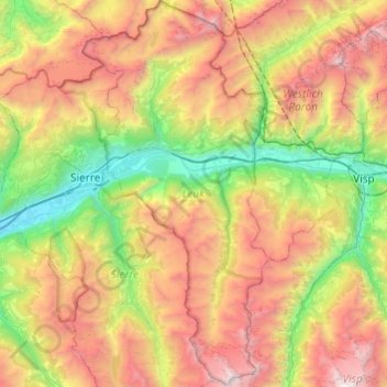
Name: Leuk topographic map, elevation, terrain.
Location: Leuk, Wallis, Switzerland (46.11075 7.52860 46.44505 7.76248)
Average elevation: 2,007 m
Minimum elevation: 495 m
Maximum elevation: 4,214 m
Other topographic maps
Click on a map to view its topography, its elevation and its terrain.
Mund
Switzerland > Wallis > Brig
The former municipality is located in the Brig district, on the northern slope of the Rhone valley at an elevation of about 1,200 m (3,900 ft).
Average elevation: 1,250 m
Grimselpass
Switzerland > Wallis > Goms > Obergoms
The Grimsel Pass (German: Grimselpass; French: Col du Grimsel; Italian: Passo del Grimsel) is a mountain pass in Switzerland, crossing the Bernese Alps at an elevation of 2,164 metres (7,100 ft). The pass connects the Haslital, the upper valley of the river Aare, with the upper valley of the Rhône. In so…
Average elevation: 2,154 m
Zermatt
Switzerland > Wallis > Visp > Zermatt > Zermatt
It lies at the upper end of Mattertal at an elevation of 1,620 m (5,310 ft), at the foot of Switzerland's highest peaks. It lies about 10 km (6.2 mi) from the over 3,292 m (10,801 ft) high Theodul Pass bordering Italy. Zermatt is the southernmost commune of the German Sprachraum.
Average elevation: 2,469 m
Col de la Forclaz
Switzerland > Wallis > Martigny > Trient > Col de la Forclaz
Average elevation: 1,637 m
Monte Rosa
Switzerland > Wallis > Visp > Zermatt
The peak is distinguished by the name Dufourspitze (in German, lit. Dufour Peak; French: Pointe Dufour, Italian: Punta Dufour). This replaced the former name Höchste Spitze (English: Highest Peak) that was indicated on the Swiss maps before the Federal Council, on January 28, 1863, decided to rename the…
Average elevation: 4,033 m