
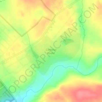
Camelot Forest topographic map
Interactive map
Click on the map to display elevation.
About this map
Name: Camelot Forest topographic map, elevation, terrain.
Average elevation: 514 m
Minimum elevation: 474 m
Maximum elevation: 548 m
Other topographic maps
Click on a map to view its topography, its elevation and its terrain.
Kalahari Indoor Waterpark
United States > Pennsylvania > Monroe County > Tobyhanna Township
Kalahari Indoor Waterpark, Kalahari Boulevard, Tobyhanna Township, Monroe County, Pennsylvania, 18346, United States
Average elevation: 553 m
Pocono Lake
United States > Pennsylvania > Monroe County > Tobyhanna Township > Pocono Pines
Pocono Lake, Pocono Pines, Tobyhanna Township, Monroe County, Pennsylvania, 18347, United States
Average elevation: 537 m
Lake Naomi
United States > Pennsylvania > Monroe County > Tobyhanna Township > Pocono Pines > Pocono Lake
Lake Naomi, Pocono Lake, Pocono Pines, Tobyhanna Township, Monroe County, Pennsylvania, 18347, United States
Average elevation: 549 m
Pocono Summit
United States > Pennsylvania > Monroe County > Tobyhanna Township
Pocono Summit, Tobyhanna Township, Monroe County, Pennsylvania, 18346, United States
Average elevation: 547 m
Blakeslee
United States > Pennsylvania > Monroe County > Tobyhanna Township
Blakeslee, Tobyhanna Township, Monroe County, Pennsylvania, 18610, United States
Average elevation: 504 m
Pocono Pines
United States > Pennsylvania > Monroe County > Tobyhanna Township
Pocono Pines, Tobyhanna Township, Monroe County, Pennsylvania, 18350, United States
Average elevation: 556 m
Pinecrest Lake
United States > Pennsylvania > Monroe County > Tobyhanna Township
Pinecrest Lake, Tobyhanna Township, Monroe County, Pennsylvania, United States
Average elevation: 556 m