
Make a donation
Gear up for your next adventure:
As an Amazon Associate, this site earns from qualifying purchases at no extra cost to you.
Rothem topographic map
Click on the map to display elevation.
Make a donation
Gear up for your next adventure:
As an Amazon Associate, this site earns from qualifying purchases at no extra cost to you.
About this map
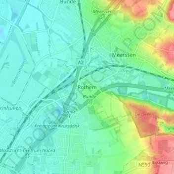
Name: Rothem topographic map, elevation, terrain.
Location: Rothem, Meerssen, Limbourg, Pays-Bas, 6231 BB, Pays-Bas (50.85765 5.71954 50.89765 5.75954)
Average elevation: 62 m
Minimum elevation: 40 m
Maximum elevation: 124 m
Make a donation
Gear up for your next adventure:
As an Amazon Associate, this site earns from qualifying purchases at no extra cost to you.
Other topographic maps
Click on a map to view its topography, its elevation and its terrain.
Make a donation
Gear up for your next adventure:
As an Amazon Associate, this site earns from qualifying purchases at no extra cost to you.
Vaals
Vaals voisine la Belgique et l'Allemagne. Les trois pays se joignent au Vaalserberg, sommet des Pays-Bas. Il est situé à 322,20 m d'altitude niveau NAP néerlandais ou NN allemand ; 324,62 m au niveau DNG belge ; ce qui correspond à 322,75 m niveau IGN69 français.
Average elevation: 198 m
Make a donation
Gear up for your next adventure:
As an Amazon Associate, this site earns from qualifying purchases at no extra cost to you.
Make a donation
Gear up for your next adventure:
As an Amazon Associate, this site earns from qualifying purchases at no extra cost to you.
Make a donation
Gear up for your next adventure:
As an Amazon Associate, this site earns from qualifying purchases at no extra cost to you.
Make a donation
Gear up for your next adventure:
As an Amazon Associate, this site earns from qualifying purchases at no extra cost to you.