
Untergriesheim topographic map
Interactive map
Click on the map to display elevation.
About this map
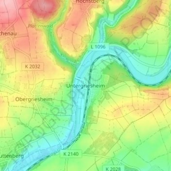
Name: Untergriesheim topographic map, elevation, terrain.
Average elevation: 206 m
Minimum elevation: 147 m
Maximum elevation: 286 m
Other topographic maps
Click on a map to view its topography, its elevation and its terrain.
Duttenberg
Deutschland > Baden-Württemberg > Landkreis Heilbronn > Bad Friedrichshall
Duttenberg, Bad Friedrichshall, Verwaltungsgemeinschaft Bad Friedrichshall, Landkreis Heilbronn, Baden-Württemberg, 74177, Deutschland
Average elevation: 183 m