
Smithton topographic map
Interactive map
Click on the map to display elevation.
About this map
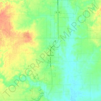
Name: Smithton topographic map, elevation, terrain.
Location: Smithton, Saint Clair County, Illinois, 62285, United States (38.36567 -90.02263 38.46034 -89.96476)
Average elevation: 147 m
Minimum elevation: 127 m
Maximum elevation: 179 m
Other topographic maps
Click on a map to view its topography, its elevation and its terrain.
O'Fallon
United States > Illinois > Saint Clair County
O'Fallon, Saint Clair County, Illinois, 62269, United States
Average elevation: 164 m