
Make a donation
Gear up for your next adventure:
As an Amazon Associate, this site earns from qualifying purchases at no extra cost to you.
Kinsau topographic map
Click on the map to display elevation.
Make a donation
Gear up for your next adventure:
As an Amazon Associate, this site earns from qualifying purchases at no extra cost to you.
About this map
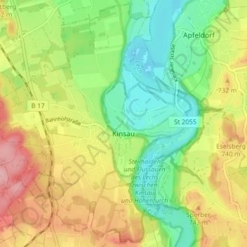
Name: Kinsau topographic map, elevation, terrain.
Average elevation: 700 m
Minimum elevation: 637 m
Maximum elevation: 780 m
Make a donation
Gear up for your next adventure:
As an Amazon Associate, this site earns from qualifying purchases at no extra cost to you.
Other topographic maps
Click on a map to view its topography, its elevation and its terrain.
Make a donation
Gear up for your next adventure:
As an Amazon Associate, this site earns from qualifying purchases at no extra cost to you.
Geretshausen
Deutschland > Bayern > Landkreis Landsberg am Lech
Das Pfarrdorf liegt etwa eineinhalb Kilometer ostsüdöstlich der Ortsmitte von Weil auf einer Höhe von 591 m ü. NHN. Naturräumlich befindet es sich im Lechrain am östlichen Hochufer des Verlorenen Baches, dem dort auch der Sägmühlbach und der Dorfgraben zufließen.
Average elevation: 588 m
Dettenschwang
Deutschland > Bayern > Landkreis Landsberg am Lech > Dießen am Ammersee
Das Pfarrdorf Dettenschwang liegt circa sechs Kilometer westlich von Dießen am Ammersee auf einem Höhenrücken in einer eiszeitlichen Jungmoränenlandschaft.
Average elevation: 675 m
Make a donation
Gear up for your next adventure:
As an Amazon Associate, this site earns from qualifying purchases at no extra cost to you.
Make a donation
Gear up for your next adventure:
As an Amazon Associate, this site earns from qualifying purchases at no extra cost to you.
Thalhofen
Deutschland > Bayern > Landkreis Landsberg am Lech > Landsberg am Lech
Average elevation: 641 m
Riederau
Deutschland > Bayern > Landkreis Landsberg am Lech > Dießen am Ammersee
Average elevation: 563 m
Make a donation
Gear up for your next adventure:
As an Amazon Associate, this site earns from qualifying purchases at no extra cost to you.
Hechenwang
Deutschland > Bayern > Landkreis Landsberg am Lech
Das Kirchdorf liegt auf einer Höhe von 594 m ü. NHN etwa zwei Kilometer südöstlich vom Gemeindehauptort Windach und zwei Kilometer westlich von Schondorf am Ammersee am Lauf der Schweinach.
Average elevation: 584 m
Oberbeuern
Deutschland > Bayern > Landkreis Landsberg am Lech > Dießen am Ammersee
Average elevation: 650 m
Lechrain
Deutschland > Bayern > Landkreis Landsberg am Lech > Denklingen > Guttenstall
Average elevation: 685 m
Make a donation
Gear up for your next adventure:
As an Amazon Associate, this site earns from qualifying purchases at no extra cost to you.
Erpfting
Deutschland > Bayern > Landkreis Landsberg am Lech > Landsberg am Lech
Average elevation: 628 m
Pessenhausen
Deutschland > Bayern > Landkreis Landsberg am Lech > Pessenhausen
Average elevation: 706 m
Make a donation
Gear up for your next adventure:
As an Amazon Associate, this site earns from qualifying purchases at no extra cost to you.
Dettenhofen
Deutschland > Bayern > Landkreis Landsberg am Lech > Dießen am Ammersee
Average elevation: 662 m