
Ardens Grafton topographic map
Interactive map
Click on the map to display elevation.
About this map
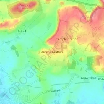
Name: Ardens Grafton topographic map, elevation, terrain.
Average elevation: 65 m
Minimum elevation: 34 m
Maximum elevation: 116 m
Other topographic maps
Click on a map to view its topography, its elevation and its terrain.
Barcheston
United Kingdom > England > Warwickshire > Stratford-on-Avon > Willington
Barcheston, Willington, Stratford-on-Avon, Warwickshire, England, United Kingdom
Average elevation: 82 m
Edgehill
United Kingdom > England > Warwickshire > Stratford-on-Avon > Radway
Edgehill, Ratley and Upton CP, Radway, Stratford-on-Avon, Warwickshire, England, OX15 6EB, United Kingdom
Average elevation: 157 m
Ratley
United Kingdom > England > Warwickshire > Stratford-on-Avon
Ratley, Stratford-on-Avon, Warwickshire, England, OX15 6DS, United Kingdom
Average elevation: 163 m
Lower Quinton
United Kingdom > England > Warwickshire > Stratford-on-Avon
Lower Quinton, Stratford-on-Avon, Warwickshire, England, CV37 8UZ, United Kingdom
Average elevation: 64 m
Preston Green
United Kingdom > England > Warwickshire > Stratford-on-Avon
Preston Green, Stratford-on-Avon, Warwickshire, England, B95 5DP, United Kingdom
Average elevation: 88 m
Priors Marston
United Kingdom > England > Warwickshire > Stratford-on-Avon
Priors Marston, Stratford-on-Avon, Warwickshire, England, CV47 7RR, United Kingdom
Average elevation: 151 m
Spernal
United Kingdom > England > Warwickshire > Stratford-on-Avon
Spernal, Spernall, Stratford-on-Avon, Warwickshire, England, B80 7ET, United Kingdom
Average elevation: 73 m
Farnborough CP
United Kingdom > England > Warwickshire > Stratford-on-Avon
Farnborough CP, Stratford-on-Avon, Warwickshire, England, United Kingdom
Average elevation: 143 m
Botley Hill
United Kingdom > England > Warwickshire > Stratford-on-Avon
Botley Hill, Stratford-on-Avon, Warwickshire, England, B95 5QY, United Kingdom
Average elevation: 101 m
Long Itchington
United Kingdom > England > Warwickshire > Stratford-on-Avon
Long Itchington, Stratford-on-Avon, Warwickshire, England, CV47 9PL, United Kingdom
Average elevation: 80 m
Butlers Marston
United Kingdom > England > Warwickshire > Stratford-on-Avon
Butlers Marston, Stratford-on-Avon, Warwickshire, England, United Kingdom
Average elevation: 93 m
Arrow
United Kingdom > England > Warwickshire > Stratford-on-Avon
Arrow, Stratford-on-Avon, Warwickshire, England, B49 5PJ, United Kingdom
Average elevation: 61 m
Little Wolford
United Kingdom > England > Warwickshire > Stratford-on-Avon
Little Wolford, Stratford-on-Avon, Warwickshire, England, CV36 5NB, United Kingdom
Average elevation: 103 m
Stratford-on-Avon
United Kingdom > England > Warwickshire > Stratford-on-Avon
Stratford-on-Avon, Warwickshire, West Midlands, England, United Kingdom
Average elevation: 108 m
Oversley Wood
United Kingdom > England > Warwickshire > Stratford-on-Avon > Alcester > Exhall
Oversley Wood, Alcester, Exhall, Stratford-on-Avon, Warwickshire, England, United Kingdom
Average elevation: 64 m
Cranhill
United Kingdom > England > Warwickshire > Stratford-on-Avon > Ardens Grafton
Cranhill, Temple Grafton CP, Ardens Grafton, Stratford-on-Avon, Warwickshire, England, B50 4LW, United Kingdom
Average elevation: 57 m
Napton Hill
United Kingdom > England > Warwickshire > Stratford-on-Avon
Napton Hill, Stratford-on-Avon, Warwickshire, England, CV47 8PG, United Kingdom
Average elevation: 103 m
Lighthorne
United Kingdom > England > Warwickshire > Stratford-on-Avon
Lighthorne, Stratford-on-Avon, Warwickshire, England, United Kingdom
Average elevation: 105 m
Southam CP
United Kingdom > England > Warwickshire > Stratford-on-Avon
Southam CP, Stratford-on-Avon, Warwickshire, England, United Kingdom
Average elevation: 91 m
Burton Dassett Hills Country Park
United Kingdom > England > Warwickshire > Stratford-on-Avon > Northend > Burton Dassett CP
Burton Dassett Hills Country Park, Burton Dassett CP, Northend, Stratford-on-Avon, Warwickshire, West Midlands, England, United Kingdom
Average elevation: 132 m
Barton-on-the-Heath
United Kingdom > England > Warwickshire > Stratford-on-Avon
Barton-on-the-Heath, Stratford-on-Avon, Warwickshire, England, United Kingdom
Average elevation: 130 m
Shipston-on-Stour
United Kingdom > England > Warwickshire > Stratford-on-Avon
Shipston-on-Stour, Stratford-on-Avon, Warwickshire, England, CV36 4AJ, United Kingdom
Average elevation: 83 m
Chadshunt
United Kingdom > England > Warwickshire > Stratford-on-Avon
Chadshunt, Chadshunt CP, Stratford-on-Avon, Warwickshire, England, CV35 0EH, United Kingdom
Average elevation: 105 m
Shelfield
United Kingdom > England > Warwickshire > Stratford-on-Avon
Shelfield, Aston Cantlow CP, Stratford-on-Avon, Warwickshire, England, B49 6JW, United Kingdom
Average elevation: 87 m
Wormleighton
United Kingdom > England > Warwickshire > Stratford-on-Avon
Wormleighton, Wormleighton CP, Stratford-on-Avon, Warwickshire, England, CV47 2XG, United Kingdom
Average elevation: 128 m
Welford on Avon CP
United Kingdom > England > Warwickshire > Stratford-on-Avon
Welford on Avon CP, Stratford-on-Avon, Warwickshire, England, United Kingdom
Average elevation: 44 m
Luddington CP
United Kingdom > England > Warwickshire > Stratford-on-Avon
Luddington CP, Stratford-on-Avon, Warwickshire, England, United Kingdom
Average elevation: 47 m
Salford Priors CP
United Kingdom > England > Warwickshire > Stratford-on-Avon
Salford Priors CP, Stratford-on-Avon, Warwickshire, England, United Kingdom
Average elevation: 47 m
Halford CP
United Kingdom > England > Warwickshire > Stratford-on-Avon
Halford CP, Stratford-on-Avon, Warwickshire, England, United Kingdom
Average elevation: 70 m
Stratford-upon-Avon
United Kingdom > England > Warwickshire > Stratford-on-Avon
Stratford-upon-Avon, Stratford-on-Avon, Warwickshire, England, United Kingdom
Average elevation: 61 m
Priors Hardwick CP
United Kingdom > England > Warwickshire > Stratford-on-Avon
Priors Hardwick CP, Stratford-on-Avon, Warwickshire, England, United Kingdom
Average elevation: 134 m
Newbold on Stour
United Kingdom > England > Warwickshire > Stratford-on-Avon
Newbold on Stour, Stratford-on-Avon, Warwickshire, England, CV37 8UA, United Kingdom
Average elevation: 69 m
Stretton-on-Fosse
United Kingdom > England > Warwickshire > Stratford-on-Avon
Stretton-on-Fosse, Stratford-on-Avon, Warwickshire, England, United Kingdom
Average elevation: 108 m
Gaydon
United Kingdom > England > Warwickshire > Stratford-on-Avon > Gaydon
Gaydon, Stratford-on-Avon, Warwickshire, England, United Kingdom
Average elevation: 109 m
Warmington CP
United Kingdom > England > Warwickshire > Stratford-on-Avon
Warmington CP, Stratford-on-Avon, Warwickshire, England, United Kingdom
Average elevation: 145 m
Ladbroke CP
United Kingdom > England > Warwickshire > Stratford-on-Avon
Ladbroke CP, Stratford-on-Avon, Warwickshire, England, United Kingdom
Average elevation: 98 m
Long Marston CP
United Kingdom > England > Warwickshire > Stratford-on-Avon
Long Marston CP, Stratford-on-Avon, Warwickshire, England, United Kingdom
Average elevation: 45 m
Stockton CP
United Kingdom > England > Warwickshire > Stratford-on-Avon
Stockton CP, Stratford-on-Avon, Warwickshire, England, United Kingdom
Average elevation: 93 m
Alcester
United Kingdom > England > Warwickshire > Stratford-on-Avon
Alcester, Stratford-on-Avon, Warwickshire, England, United Kingdom
Average elevation: 62 m
Studley CP
United Kingdom > England > Warwickshire > Stratford-on-Avon
Studley CP, Stratford-on-Avon, Warwickshire, England, United Kingdom
Average elevation: 81 m
Lye Green
United Kingdom > England > Warwickshire > Stratford-on-Avon > Claverdon > Lye Green
Lye Green, Claverdon CP, Claverdon, Stratford-on-Avon, Warwickshire, England, CV35 8HL, United Kingdom
Average elevation: 106 m
Upper Quinton
United Kingdom > England > Warwickshire > Stratford-on-Avon > Lower Quinton > Upper Quinton
Upper Quinton, Quinton CP, Lower Quinton, Stratford-on-Avon, Warwickshire, England, CV37 8SX, United Kingdom
Average elevation: 70 m
Winderton
United Kingdom > England > Warwickshire > Stratford-on-Avon > Winderton
Winderton, Brailes, Stratford-on-Avon, Warwickshire, England, OX15 5JG, United Kingdom
Average elevation: 151 m
Kineton CP
United Kingdom > England > Warwickshire > Stratford-on-Avon
Kineton CP, Stratford-on-Avon, Warwickshire, England, United Kingdom
Average elevation: 93 m
Upton
United Kingdom > England > Warwickshire > Stratford-on-Avon > Upton
Haselor CP, Upton, Stratford-on-Avon, Warwickshire, England, United Kingdom
Average elevation: 67 m
Bishop's Itchington
United Kingdom > England > Warwickshire > Stratford-on-Avon > Bishop's Itchington
Bishop's Itchington, Stratford-on-Avon, Warwickshire, England, CV47 2DR, United Kingdom
Average elevation: 105 m
Middle Tysoe
United Kingdom > England > Warwickshire > Stratford-on-Avon
Middle Tysoe, Stratford-on-Avon, Warwickshire, England, CV35 0SR, United Kingdom
Average elevation: 135 m
Ladbroke (Millennium Green)
United Kingdom > England > Warwickshire > Stratford-on-Avon > Ladbroke CP
Ladbroke (Millennium Green), Ladbroke CP, Stratford-on-Avon, Warwickshire, West Midlands, England, United Kingdom
Average elevation: 98 m
Meon Vale
United Kingdom > England > Warwickshire > Stratford-on-Avon > Meon Vale
Meon Vale, Stratford-on-Avon, Warwickshire, West Midlands, England, CV37 8WR, United Kingdom
Average elevation: 61 m
Harbury
United Kingdom > England > Warwickshire > Stratford-on-Avon
Harbury, Stratford-on-Avon, Warwickshire, England, United Kingdom
Average elevation: 95 m