
Changyi City topographic map
Interactive map
Click on the map to display elevation.
About this map
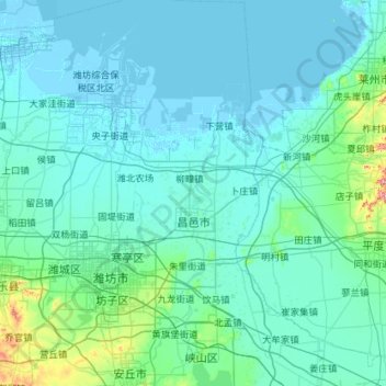
Name: Changyi City topographic map, elevation, terrain.
Location: Changyi City, Weifang, Shandong, China (36.44671 119.21119 37.35979 119.61893)
Average elevation: 25 m
Minimum elevation: -4 m
Maximum elevation: 412 m
Other topographic maps
Click on a map to view its topography, its elevation and its terrain.
Tai'an City
China > Shandong > Tai'an City
Tai'an City, Shandong, 271000, China
Average elevation: 161 m