
Sulawesi topographic map
Interactive map
Click on the map to display elevation.
About this map
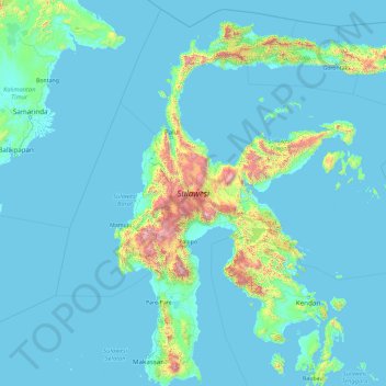
Name: Sulawesi topographic map, elevation, terrain.
Location: Sulawesi, Poso, Sulteng, Indonesia (-5.70288 118.75665 1.75131 125.24781)
Average elevation: 145 m
Minimum elevation: -3 m
Maximum elevation: 3,405 m
Other topographic maps
Click on a map to view its topography, its elevation and its terrain.