
Town of Philipstown topographic map
Interactive map
Click on the map to display elevation.
About this map
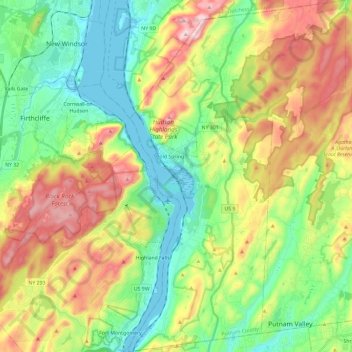
Name: Town of Philipstown topographic map, elevation, terrain.
Location: Town of Philipstown, Putnam County, New York, United States (41.32178 -73.98253 41.49854 -73.83707)
Average elevation: 178 m
Minimum elevation: -3 m
Maximum elevation: 478 m
Other topographic maps
Click on a map to view its topography, its elevation and its terrain.