Newton topographic map
Interactive map
Click on the map to display elevation.
About this map
![Newton topographic map, elevation, terrain](/pub/maps/relation/47gp/lvr6f3/thumbnail.jpg)
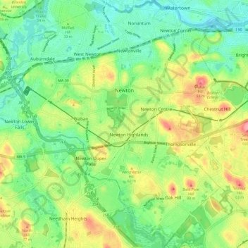
Name: Newton topographic map, elevation, terrain.
Location: Newton, Middlesex County, Massachusetts, United States (42.28294 -71.27033 42.36783 -71.15689)
Average elevation: 38 m
Minimum elevation: 0 m
Maximum elevation: 102 m
Newton has grown around a formation of seven hills. "The general features of Newton are not without interest. Seven principal elevations mark its surface, like the seven hills of ancient Rome, with the difference that the seven hills of Newton are much more distinct than the seven hills of Rome: Nonantum Hill, Waban Hill, Chestnut Hill, Bald Pate, Oak Hill, Institution Hill and Mount Ida."
Other topographic maps
Click on a map to view its topography, its elevation and its terrain.
![Somerville topographic map, elevation, terrain](/pub/maps/relation/7qkl/mcd6nh/icon.jpg)
Somerville
United States > Massachusetts > Middlesex County
Somerville, Middlesex County, Massachusetts, United States
Average elevation: 11 m
![Holliston topographic map, elevation, terrain](/pub/maps/relation/s1tp/mjwgnh/icon.jpg)
Holliston
United States > Massachusetts > Middlesex County
Holliston, Middlesex County, Massachusetts, 01746, United States
Average elevation: 72 m
![Little Desert topographic map, elevation, terrain](/pub/maps/way/x9s8/88zgjtj/icon.jpg)
Little Desert
United States > Massachusetts > Middlesex County > Westford
Little Desert, Westford, Middlesex County, Massachusetts, United States
Average elevation: 66 m
![Flagstaff Hill topographic map, elevation, terrain](/pub/maps/node/gqzs/nr1mqt6/icon.jpg)
Flagstaff Hill
United States > Massachusetts > Middlesex County > Medford
Flagstaff Hill, Medford, Middlesex County, Massachusetts, 01890, United States
Average elevation: 28 m
![Bowman Park topographic map, elevation, terrain](/pub/maps/way/3s51/wnjvwnx/icon.jpg)
Bowman Park
United States > Massachusetts > Middlesex County > Lexington > East Lexington
Bowman Park, East Lexington, Lexington, Middlesex County, Massachusetts, United States
Average elevation: 70 m
![Cambridge topographic map, elevation, terrain](/pub/maps/relation/mkmt/fnxw4s/icon.jpg)
Cambridge
United States > Massachusetts > Middlesex County
Cambridge, Middlesex County, Massachusetts, United States
Average elevation: 11 m
![Bedford topographic map, elevation, terrain](/pub/maps/relation/x4b3/frg44s/icon.jpg)
Bedford
United States > Massachusetts > Middlesex County
Bedford, Middlesex County, Massachusetts, 01730, United States
Average elevation: 45 m
![Lexington topographic map, elevation, terrain](/pub/maps/relation/h51/rd3rcz/icon.jpg)
Lexington
United States > Massachusetts > Middlesex County
Lexington, Middlesex County, Massachusetts, United States
Average elevation: 62 m
![Westford topographic map, elevation, terrain](/pub/maps/relation/3zm2/9ngb57/icon.jpg)
Westford
United States > Massachusetts > Middlesex County
Westford, Middlesex County, Massachusetts, 01886, United States
Average elevation: 69 m
![Sudbury topographic map, elevation, terrain](/pub/maps/relation/9ftf/hg3tmt/icon.jpg)
Sudbury
United States > Massachusetts > Middlesex County
Sudbury, Middlesex County, Massachusetts, 01776, United States
Average elevation: 57 m
![Tewksbury topographic map, elevation, terrain](/pub/maps/relation/wmzs/4b61tp/icon.jpg)
Tewksbury
United States > Massachusetts > Middlesex County > Tewksbury
Tewksbury, Middlesex County, Massachusetts, United States
Average elevation: 42 m
![Pepperell topographic map, elevation, terrain](/pub/maps/relation/9t9m/zs22tj/icon.jpg)
Pepperell
United States > Massachusetts > Middlesex County
Pepperell, Middlesex County, Massachusetts, United States
Average elevation: 90 m
![Billerica topographic map, elevation, terrain](/pub/maps/relation/r7nx/m57vnh/icon.jpg)
Billerica
United States > Massachusetts > Middlesex County > Billerica
Billerica, Middlesex County, Massachusetts, United States
Average elevation: 47 m
![Somerville topographic map, elevation, terrain](/pub/maps/node/p3gt/b4ntzt6/icon.jpg)
Somerville
United States > Massachusetts > Middlesex County > Somerville
Somerville, Middlesex County, Massachusetts, 02143, United States
Average elevation: 29 m
![Lowell topographic map, elevation, terrain](/pub/maps/node/d4b3/nkstk3q/icon.jpg)
Lowell
United States > Massachusetts > Middlesex County > Lowell
Lowell, Middlesex County, Massachusetts, 01852-9998, United States
Average elevation: 55 m
![Wilmington topographic map, elevation, terrain](/pub/maps/relation/gpnx/szjw18/icon.jpg)
Wilmington
United States > Massachusetts > Middlesex County > Wilmington
Wilmington, Middlesex County, Massachusetts, United States
Average elevation: 34 m
![Holden Hill topographic map, elevation, terrain](/pub/maps/node/x3q/4fc1fwm2/icon.jpg)
Holden Hill
United States > Massachusetts > Middlesex County > Concord
Holden Hill, Concord, Middlesex County, Massachusetts, 01741, United States
Average elevation: 45 m
![Townsend topographic map, elevation, terrain](/pub/maps/relation/xp18/6299tf/icon.jpg)
Townsend
United States > Massachusetts > Middlesex County > Townsend
Townsend, Middlesex County, Massachusetts, United States
Average elevation: 135 m
![Watertown topographic map, elevation, terrain](/pub/maps/relation/wr57/4zfftp/icon.jpg)
Watertown
United States > Massachusetts > Middlesex County
Watertown, Middlesex County, Massachusetts, United States
Average elevation: 26 m
![Ashland topographic map, elevation, terrain](/pub/maps/relation/5qnx/pgdrdn/icon.jpg)
Ashland
United States > Massachusetts > Middlesex County
Ashland, Middlesex County, Massachusetts, 01721, United States
Average elevation: 81 m
![Medford topographic map, elevation, terrain](/pub/maps/relation/fg4s/hq3sgt/icon.jpg)
Medford
United States > Massachusetts > Middlesex County
Medford, Middlesex County, Massachusetts, 02155, United States
Average elevation: 23 m
![Marlborough topographic map, elevation, terrain](/pub/maps/relation/6kzs/gm16nx/icon.jpg)
Marlborough
United States > Massachusetts > Middlesex County
Marlborough, Middlesex County, Massachusetts, United States
Average elevation: 95 m
![Melrose topographic map, elevation, terrain](/pub/maps/relation/v6m2/4bw7gp/icon.jpg)
Melrose
United States > Massachusetts > Middlesex County
Melrose, Middlesex County, Massachusetts, 02176, United States
Average elevation: 38 m
![Ayer topographic map, elevation, terrain](/pub/maps/relation/klkl/knwdt6/icon.jpg)
Ayer
United States > Massachusetts > Middlesex County
Ayer, Middlesex County, Massachusetts, 01432, United States
Average elevation: 87 m