
Le Barry topographic map
Interactive map
Click on the map to display elevation.
About this map
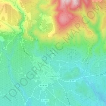
Name: Le Barry topographic map, elevation, terrain.
Average elevation: 211 m
Minimum elevation: 81 m
Maximum elevation: 487 m
Other topographic maps
Click on a map to view its topography, its elevation and its terrain.
Saint-Étienne-les-Bains
France > Occitanie > Hérault > Montpeyroux
Saint-Étienne-les-Bains, Montpeyroux, Lodève, Hérault, Occitanie, France métropolitaine, 34150, France
Average elevation: 115 m
Le Castellas
France > Occitanie > Hérault > Montpeyroux > Le Barry
Le Castellas, Le Barry, Montpeyroux, Lodève, Hérault, Occitanie, France métropolitaine, 34150, France
Average elevation: 218 m