Geolocate

Lossiemouth topographic map

Interactive map

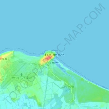
Click on the map to display elevation.

About this map

Name: Lossiemouth topographic map, elevation, terrain.

Location: Lossiemouth, Moray, Scotland, IV31 6NU, United Kingdom (57.68208 -3.32146 57.76208 -3.24146)

Average elevation: 3 m

Minimum elevation: -2 m

Maximum elevation: 38 m

Other topographic maps

Click on a map to view its topography, its elevation and its terrain.

Keith

United Kingdom > Scotland > Moray

Keith, Moray, Scotland, AB55 5FF, United Kingdom

Average elevation: 180 m

Findhorn Ecovillage

United Kingdom > Scotland > Moray > Findhorn > Findhorn Ecovillage

Findhorn Ecovillage, Findhorn, Moray, Scotland, IV36 3TZ, United Kingdom

Average elevation: 3 m

Forres

United Kingdom > Scotland > Moray > Forres

Forres, Moray, Scotland, IV36 1NX, United Kingdom

Average elevation: 31 m