
Loamneș topographic map
Interactive map
Click on the map to display elevation.
About this map
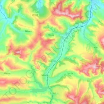
Name: Loamneș topographic map, elevation, terrain.
Location: Loamneș, Sibiu, Romania (45.90461 23.93081 46.00690 24.12106)
Average elevation: 429 m
Minimum elevation: 322 m
Maximum elevation: 579 m
Other topographic maps
Click on a map to view its topography, its elevation and its terrain.
Bâlea Lake
Romania > Sibiu > Cârțișoara
Bâlea Lake, Cârțișoara, Sibiu, Romania
Average elevation: 2,080 m