
Winkelsett topographic map
Interactive map
Click on the map to display elevation.
About this map
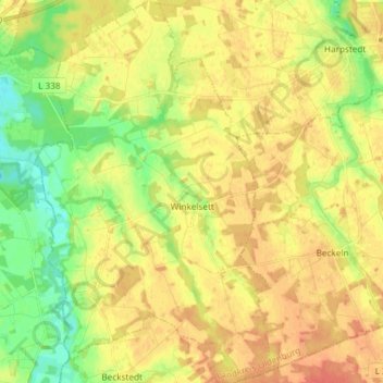
Name: Winkelsett topographic map, elevation, terrain.
Average elevation: 39 m
Minimum elevation: 17 m
Maximum elevation: 55 m
Other topographic maps
Click on a map to view its topography, its elevation and its terrain.
Hatten
Deutschland > Niedersachsen > Landkreis Oldenburg
Hatten, Landkreis Oldenburg, Niedersachsen, 26209, Deutschland
Average elevation: 18 m
Tungeln
Deutschland > Niedersachsen > Landkreis Oldenburg > Wardenburg
Tungeln, Wardenburg, Landkreis Oldenburg, Niedersachsen, Deutschland
Average elevation: 6 m