
Riudaura topographic map
Interactive map
Click on the map to display elevation.
About this map
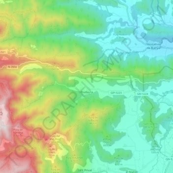
Name: Riudaura topographic map, elevation, terrain.
Location: Riudaura, Garrotxa, Gerona, Cataluña, España (42.16680 2.33219 42.21582 2.44682)
Average elevation: 693 m
Minimum elevation: 346 m
Maximum elevation: 1,439 m
Other topographic maps
Click on a map to view its topography, its elevation and its terrain.
Sales de Llierca
Sales de Llierca, Garrotxa, Gerona, Cataluña, España
Average elevation: 510 m
Sant Privat d'En Bas
España > Cataluña > Garrotxa > la Vall d'en Bas
Sant Privat d'En Bas, la Vall d'en Bas, Garrotxa, Gerona, Cataluña, 17178, España
Average elevation: 735 m