
East Bay Township topographic map
Interactive map
Click on the map to display elevation.
About this map
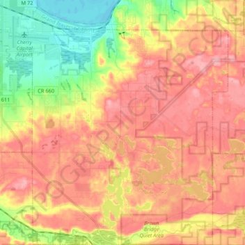
Name: East Bay Township topographic map, elevation, terrain.
Average elevation: 252 m
Minimum elevation: 175 m
Maximum elevation: 310 m
Other topographic maps
Click on a map to view its topography, its elevation and its terrain.
Grand Traverse Bay
United States > Michigan > Grand Traverse County
Grand Traverse Bay, Grand Traverse County, Michigan, 49682, United States
Average elevation: 201 m
Interlochen
United States > Michigan > Grand Traverse County
Interlochen, Green Lake Township, Grand Traverse County, Michigan, 49643, United States
Average elevation: 257 m
Williamsburg
United States > Michigan > Grand Traverse County
Williamsburg, Whitewater Township, Grand Traverse County, Michigan, 49690, United States
Average elevation: 228 m
Traverse City
United States > Michigan > Grand Traverse County
Traverse City, Grand Traverse County, Michigan, United States
Average elevation: 204 m