
Pregasina topographic map
Interactive map
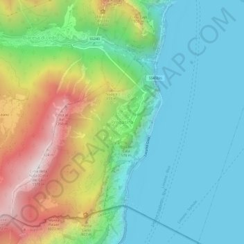
Click on the map to display elevation.
About this map
Name: Pregasina topographic map, elevation, terrain.
Average elevation: 454 m
Minimum elevation: 56 m
Maximum elevation: 1,356 m
Der Ort liegt oberhalb des Gardasee-Westufers zwischen Riva del Garda und Limone sul Garda auf einer Höhe von 532 m s.l.m. Pregasina grenzt im Westen und Norden an die Gemeinde Ledro und im Osten in der Seemitte an Nago-Torbole und bildet somit eine Exklave von Riva del Garda. Die Gemeindegrenze im Süden zu Limone sul Garda bildet gleichzeitig die Grenze zwischen dem Trentino und der Provinz Brescia.
Other topographic maps
Click on a map to view its topography, its elevation and its terrain.
Alboletta
Italien > Trentino-Südtirol > Autonome Provinz Trient > Riva del Garda > Sant'Alessandro
Alboletta, Sant'Alessandro, Riva del Garda, Comunità Alto Garda e Ledro, Autonome Provinz Trient, Trentino-Südtirol, 38066, Italien
Average elevation: 239 m