
Chapais topographic map
Interactive map
Click on the map to display elevation.
About this map
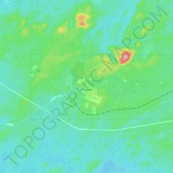
Name: Chapais topographic map, elevation, terrain.
Location: Chapais, Jamésie, Nord-du-Québec, Quebec, G0W 1H0, Canada (49.76285 -74.91543 49.80683 -74.73459)
Average elevation: 383 m
Minimum elevation: 350 m
Maximum elevation: 546 m
Other topographic maps
Click on a map to view its topography, its elevation and its terrain.
Lac Genève
Lac Genève, Eeyou Istchee James Bay, Jamésie, Nord-du-Québec, Quebec, Canada
Average elevation: 411 m
Eeyou Istchee James Bay
Eeyou Istchee James Bay, Jamésie, Northern Quebec, Quebec, Canada
Average elevation: 232 m
Île de l'Amiante
Canada > Quebec > Jamésie > Chibougamau
Île de l'Amiante, Chibougamau, Eeyou Istchee James Bay, Jamésie, Nord-du-Québec, Quebec, Canada
Average elevation: 415 m