
Thank you for supporting this site ❤️
Make a donation
Make a donation
Gear up for your next adventure:
As an Amazon Associate, this site earns from qualifying purchases at no extra cost to you.
Sandgate topographic map
Click on the map to display elevation.
Thank you for supporting this site ❤️
Make a donation
Make a donation
Gear up for your next adventure:
As an Amazon Associate, this site earns from qualifying purchases at no extra cost to you.
About this map
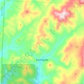
Name: Sandgate topographic map, elevation, terrain.
Location: Sandgate, Bennington County, Vermont, United States (43.12046 -73.26410 43.21703 -73.13014)
Average elevation: 480 m
Minimum elevation: 193 m
Maximum elevation: 1,002 m
Thank you for supporting this site ❤️
Make a donation
Make a donation
Gear up for your next adventure:
As an Amazon Associate, this site earns from qualifying purchases at no extra cost to you.
Other topographic maps
Click on a map to view its topography, its elevation and its terrain.
MacIntyre
United States > Vermont > Bennington County > Sunderland > MacIntyre
Average elevation: 744 m