
Thank you for supporting this site ❤️
Make a donation
Make a donation
Gear up for your next adventure:
As an Amazon Associate, this site earns from qualifying purchases at no extra cost to you.
M'Ziraa topographic map
Click on the map to display elevation.
Thank you for supporting this site ❤️
Make a donation
Make a donation
Gear up for your next adventure:
As an Amazon Associate, this site earns from qualifying purchases at no extra cost to you.
About this map
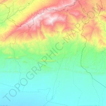
Name: M'Ziraa topographic map, elevation, terrain.
Location: M'Ziraa, Zeribet El Oued District, Biskra, Algeria (34.69159 6.10247 35.08168 6.47118)
Average elevation: 549 m
Minimum elevation: 2 m
Maximum elevation: 1,925 m
Thank you for supporting this site ❤️
Make a donation
Make a donation
Gear up for your next adventure:
🎒40L Day Hiking Backpacks - Comfortable packs with hydration support for long days exploring topographic peaks
As an Amazon Associate, this site earns from qualifying purchases at no extra cost to you.