
Thank you for supporting this site ❤️
Make a donation
Make a donation
Gear up for your next adventure:
As an Amazon Associate, this site earns from qualifying purchases at no extra cost to you.
Peraboa topographic map
Click on the map to display elevation.
Thank you for supporting this site ❤️
Make a donation
Make a donation
Gear up for your next adventure:
As an Amazon Associate, this site earns from qualifying purchases at no extra cost to you.
About this map
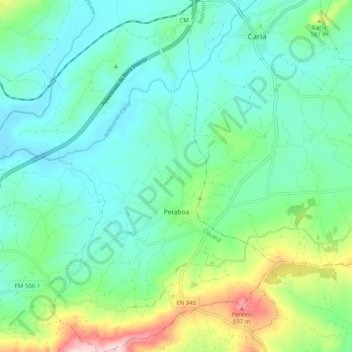
Name: Peraboa topographic map, elevation, terrain.
Location: Peraboa, Covilhã, Castelo Branco, 6200-591, Portugal (40.22558 -7.44149 40.30285 -7.35822)
Average elevation: 492 m
Minimum elevation: 416 m
Maximum elevation: 730 m
Thank you for supporting this site ❤️
Make a donation
Make a donation
Gear up for your next adventure:
As an Amazon Associate, this site earns from qualifying purchases at no extra cost to you.